Award Winning Forest Alert System
NCEO / Centre of Landscape and Climate Research (CLCR) / University of Leicester
Climate Research (CLCR) and NCEO Scientists at the University of Leicester have developed a near-real-time, forest-cover change, early-warning system. It integrates cloud computing, mobile technology and community participation to provide a more robust forest monitoring system for Kenya. The Forest Alert System sends out rapid deforestation alerts to a mobile app and enables communication with thousands of app users in the field via a central dashboard. This enables effective protection of forest assets from illegal logging.
Whilst a centralised alert system is undoubtedly useful, communities and forest workers need accessible information on their forest areas without specialist training, in the form of digital maps of forest cover change, summary statistics of forest cover change and geographic coordinates of any identified changes. This requires value adding to forest-cover change maps. Smartphone apps offer easy access to such information, facilitating quick field verification of EO-based data as well as information on the causes.
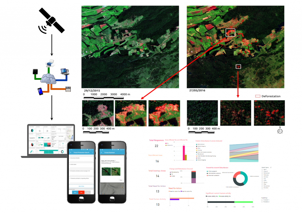
The system provides near-real-time deforestation alerts – and unprecedented spatial resolution of 10 metres allows detection of small-scale forest degradation and selective logging of single large trees in tropical rainforests.
"In the Centre for Landscape and Climate Research at the University of Leicester, we have developed a near real-time forest cover change early-warning system together with the Kenya Forest Service. It integrates cloud computing, mobile technology and community participation to provide a rapid-response forest monitoring system for Kenya.
“Near-real-time deforestation alerts are sent out whenever a new satellite image is acquired, up to every five days from the Sentinel-2 A and B satellites, within 24 hours of imaging. They are downloaded, processed and turned into actionable forest information automatically.”Professor Balzter
The project ‘REDD+ Monitoring Services with Satellite Earth Observation – Community Forest Monitoring Pilot’ at CLCR is funded by NERC.