Climate change: why we should care about methane and how we measure it from space
By Cristina Ruiz Villena
As the climate crisis deepens, its devastating effects are now more evident than ever. Extreme weather events such as floods and heat waves are stronger and more frequent, and the world is finally waking up to the reality of climate change, which was long overdue. It’s time for action, so keep reading to find out why we should care about methane if we want to fix the climate issue, and how satellite instruments can really help us in our quest to reduce emissions.
The role of methane in climate change
When talking about the greenhouse gases that cause climate change, most of the attention is usually focused on carbon dioxide (CO2). This is not surprising, since CO2 is the most abundant greenhouse gas, responsible for almost three quarters of all the current global warming. Most people know that fossil fuels are largely responsible for the high CO2 concentrations in the atmosphere and that we need to transition to clean energy, among other things, to reduce emissions and stay below the Paris Agreement target of 1.5 °C warming.
However, methane (CH4) is another critically important – and perhaps a less well-known – greenhouse gas, responsible for about a quarter of total warming. The good news is that we currently have a great opportunity to limit warming if we act fast to cut methane emissions. This is because methane has a relatively short lifetime in the atmosphere of about 10 years, only a fraction of the lifetime of CO2, which can stay in the atmosphere for hundreds of years.
Moreover, methane is 86 times stronger than CO2 in terms of how much warming it causes over a 20-year period, which together with its short lifetime means that whatever methane we can avoid emitting into the atmosphere now will have a great impact in the short term to limit global warming. And, let’s be honest, we don’t have much time. Here is one of my favourite animations showing the carbon budget for the 1.5 °C target, which represents how much more carbon we can still emit into the atmosphere and not exceed that temperature target:
Sources of methane
In order to reduce methane emissions we need to know what is causing them. This is the subject of extensive research by the scientific community and their findings are regularly published in what is known as the global methane budget, which shows how much methane is produced and removed by the different sources and sinks, respectively, and is regularly updated.
The infographic below from the Global Carbon Project shows the methane budget for 2008-2017. We can see that most of the methane emitted is anthropogenic (shown in orange), that is, produced as a result of human activities, which means that we have more control over them and can take action to reduce them.
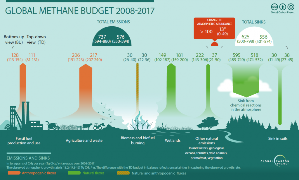
The most important human-induced methane sources include:
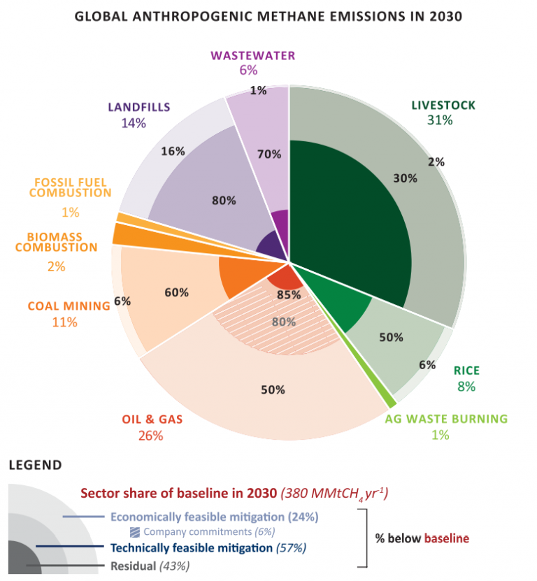
- Oil and gas production and use. Sneaky methane leaks can be found in all stages of production and transport of oil and gas, and they can be caused by a variety of reasons, some of them as trivial as faulty equipment. Sometimes, failures in gas storage facilities can have disastrous consequences. An example of such an incident is the 2015 Aliso Canyon blowout, which is considered the largest methane leak in US history. Oil and gas emissions are also often the most cost-effective to reduce, given that the methane that is not leaked can then be sold. Ilissa Ocko from the Environmental Defense Fund recently led a comprehensive study on methane mitigation that highlighted this opportunity, as the chart below illustrates.
- Agriculture. These sources include livestock belches and manure (yes, cows get their reputation for a reason, although it is not their farts!), as well as some crops like rice paddies.
- Waste. Landfill sites are not only smelly but also amongst the largest methane emitters!
Finding the leaks and how we measure methane from space
Methane sources are located all over the world, and each country takes care of (and is accountable for) their own emissions. But knowing exactly where and how much methane is being emitted is not an easy task. This is where satellite instruments come in handy, as they can measure the whole Earth, including remote places where it would be difficult or expensive to use other type of instruments.
Many satellite instruments work by measuring the solar radiation that is reflected from the Earth back into space. Molecules of atmospheric gases such as methane absorb sunlight in a very specific way that is unique to each molecule, like a fingerprint. This allows us to calculate how much gas was present when the observation was made by working out how much sunlight was absorbed. Cool, isn’t it? Earth Observation is truly fascinating – we can learn so much about our planet!
Until now, most available satellite methane measurements have been taken by high-precision scientific instruments, such as the European Space Agency’s TROPOMI aboard Sentinel-5P, and covered most of the Earth at the expense of temporal and spatial resolution. However, many methane emissions, particularly those from the oil and gas industry, come from what we call small point sources, and instruments with poor spatial resolution (with a pixel size in the order of several kilometres) cannot usually resolve them. Fortunately, several new high-resolution satellites have emerged in recent years, with pixel sizes down to a few metres. Most of them are target-based instruments, which means that they only measure areas of interest. The number high-resolution satellites that measure methane is set to almost triple in the next few years. This is great news, as these new instruments will allow us to catch many more methane leaks and hopefully take some measures to reduce them.
At NCEO we are now working with data from some of those instruments to detect methane leaks at very high spatial resolution, with a focus on the oil and gas industry. Two examples are the commercial satellite WorldView-3 (WV-3) from DigitalGlobe, with a resolution of 4 metres, and the Italian Space Agency’s PRISMA, with a resolution of 30 metres. Neither was designed for methane but they both have methane-sensitive bands and the best available spatial resolution to date. Other similar instruments include the European Space Agency’s Sentinel-2 and NASA’s Landsat-8.
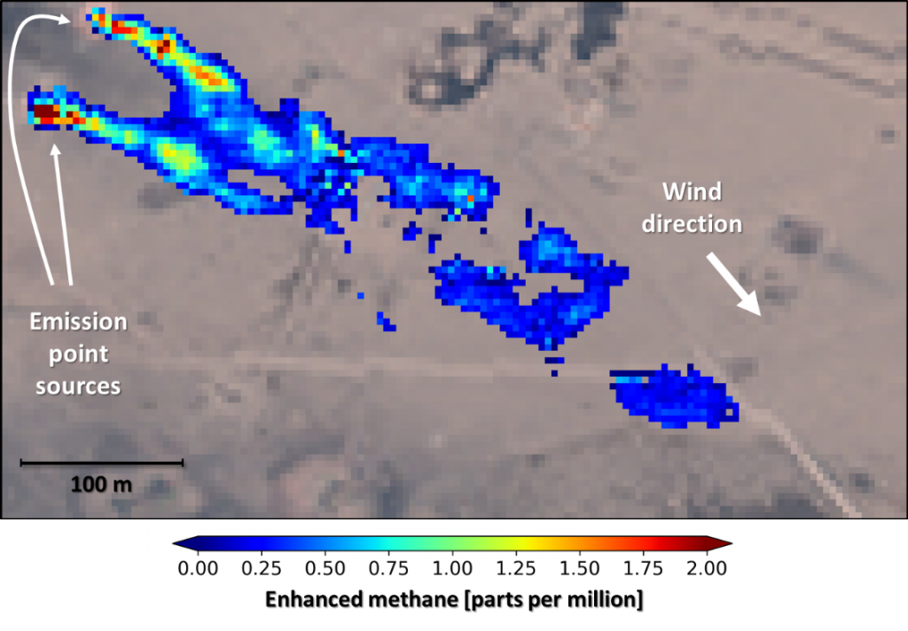
Using WV-3 data we have been able to detect and quantify some methane plumes in an oil and gas facility in the Middle East, as shown in the image below. We estimated the leaks had a joint emission rate of about 3,500 kg/h.
In a similar way, we detected a methane plume in an oil and gas facility in Turkmenistan using PRISMA observations. The plume can be seen in the centre of the figure below.

Take-home message
We can slow down global warming in a short timescale if we reduce methane emissions, most of which are man-made and come mainly from the oil and gas industry, agriculture, and waste. Satellite instruments with high spatial resolution can be a real asset to find and quantify those methane leaks so that they can be mitigated.
For further information, check out my recent talk at Pint of Science UK 2021!
Cristina Ruiz Villena is a Postdoctoral Research Associate at NCEO at the University of Leicester. She recently completed her PhD in Earth Observation, where she worked on a new instrument concept for air quality monitoring from space. Her current research focuses on satellite observations of methane.